
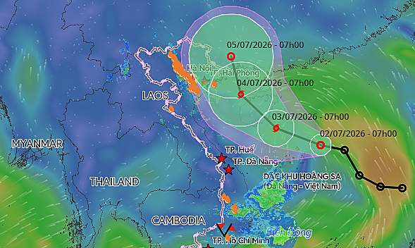
A low-pressure system in the Eastern Sea (South China Sea) is strengthening and is expected to develop into a storm by early Friday morning, then move towards the Gulf of Tonkin, causing powerful winds and turbulent waters in northern Vietnam.
The National Center for Hydro-Meteorological Forecasting identified the center of the low-pressure system about 240 kilometers northeast of the Hoang Sa (Paracel) Islands at 7:00 a.m. on Thursday.
The system was heading northwest at approximately 25 kilometers per hour, with top continuous winds ranging from 50 to 61 km/h and sudden bursts reaching as high as 75 to 88 km/h.
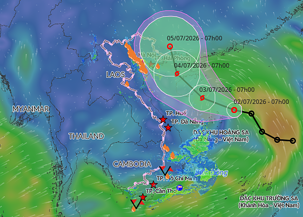
By 7:00 a.m. on Friday, the low-pressure system is predicted to develop into a tropical storm in the sea area located southeast of Hainan Island, China. The wind speed is anticipated to range from 61 to 88 kilometers per hour, with sudden bursts reaching between 103 and 133 kilometers per hour.
The storm, which marks the initial formation within Vietnam's waters this year, will keep moving northwest towards the northern areas of the Gulf of Tonkin by Saturday morning, sustaining wind speeds between 61 and 74 kilometers per hour.
|
|
The projected path of a tropical depression over the Eastern Sea. Image created by the Vietnam Disaster Surveillance System. |
International oversight organizations, such as the Japan Meteorological Agency and the Hong Kong Observatory, have issued comparable predictions, expecting the weather system to develop into a storm during the evening of Thursday prior to moving towards the Gulf of Tonkin.
Due to the approaching storm, the northern part of the South China Sea, encompassing areas near the Hoang Sa Islands, is expected to face gusty winds between 39 and 61 km/h with wave heights measuring two to four meters.
From the start of this year, one tropical depression has developed in the East Sea but has not affected Vietnam. Meteorological authorities predict that during the months of June through August, the area will experience approximately five storms and tropical depressions. This matches long-term average trends, with as many as two potentially impacting the central Vietnamese coast.
Between September and December, the number of storms and tropical depressions is expected to be lower than usual because of the effects of El Niño.
Although there is an expected decrease in total storm occurrences, the weather authority has cautioned that the dangers associated with intense local rainfalls, sudden flooding, and mudslides continue to be significant. These threats present a specific risk to the hilly areas in northern and central Vietnam.
By 2025, the East Sea experienced 21 storms and tropical depressions, which was the largest number ever documented since records started in 1961. These events resulted in 484 fatalities or disappearances and led to more than VND104.7 trillion ($4 billion) in financial damages, ranking it among the most expensive years for climate-induced destruction in Vietnam's history.